*Please click here for the shortlisted teams of the Competition and registration for the Presentation Day and Prize Award Ceremony
*Please click here for the latest arrangements on the dates and other details
About
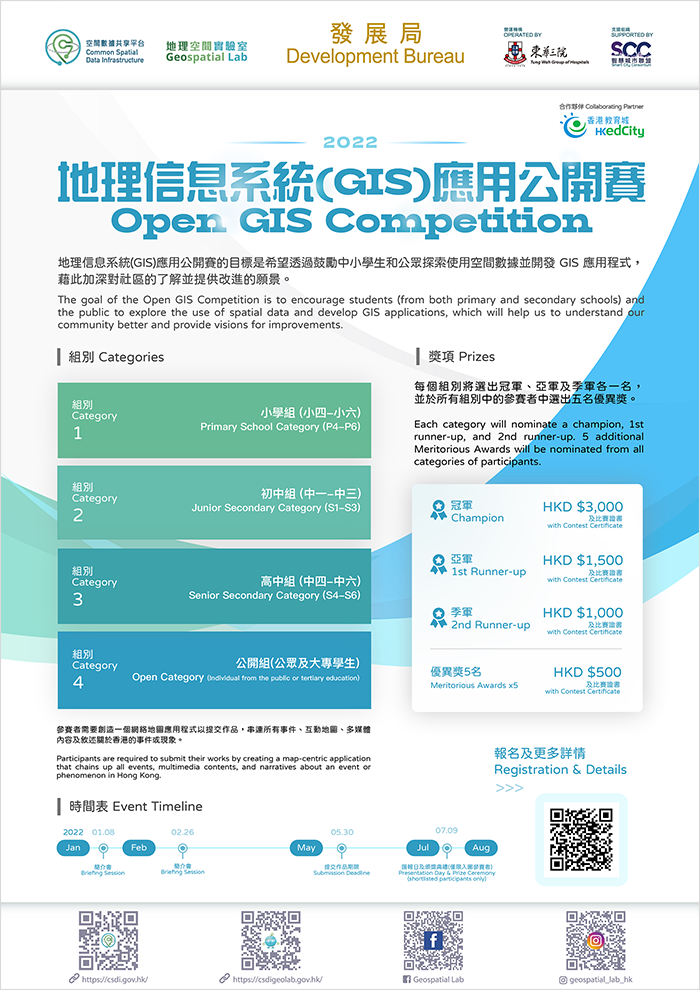
The goal of the Open GIS Competition is to encourage students (from both primary and secondary schools) and the public to explore the use of spatial data and develop GIS applications, which will help us to understand our community better and provide visions for improvements.
Participants are required to submit their works by creating a map-centric application that chains up all incidents, multimedia contents, and narratives about an event or phenomenon in Hong Kong.
Categories
Category 1: Primary School Category (P4-P6)
Category 4: Open Category (Individual from the public or tertiary education)
- Participation in the competition must be on a school basis.
- Each school can nominate a maximum of three teams and each team shall comprise of two to five students.
-
Enter the competition either as an individual or a team.
*Update: The grouping arrangement of the primary school category will be changed from two to five students to one to five student(s); there is no limit on the number of participating groups for each school
Briefing Session*
Date: (Participants may select to attend one of the following sessions)
- 8 Jan 2022 09:30 - 11:30
- 26 Feb 2022 09:30 - 11:30
- The Geospatial Lab (Units 915-918, 9/F, Tower 1, Millennium City 1, 388 Kwun Tong Road, Kwun Tong, Kowloon)
- Brief on the competition
- Examples of GIS application sharing
-
Dr Kenneth Tang, former President of HKGISA, and Adjunct Associate Professor, Department of Urban Planning and Design, University of Hong Kong
-
Dr Paulina Wong, Hon. Secretary of HKGISA and Assistant Professor, Science Unit, Lingnan University
* Optional attendance
Themes
Required skillset
Category 1
- Deliver a web base and map-centric story map
- Use a story to connect all events, maps, multimedia and narratives
- Geotagged with images, video and narrative texts
Category 2
- Deliver a web base and map-centric story map
- Use a story to connect all events, maps, multimedia and narratives
- Geotagged with images, video and narrative texts
- Thematic mapping technique to show spatial pattern
Category 3
- Deliver a web base and map-centric story map
- Use a story to connect all events, maps, multimedia and narratives
- Geotagged with images, video and narrative texts
- Thematic mapping technique to show spatial pattern
- Basic spatial analysis (e.g. clip, buffer, overlay analysis, and measure)
Category 4
- Deliver a web base and map-centric story map
- Use a story to connect all events, maps, multimedia and narratives
- Geotagged with images, video and narrative texts
- Thematic mapping technique to show spatial pattern
- Basic spatial analysis (e.g. clip, buffer, overlay analysis, and measure)
- Collect data either form own field survey or from the result of GIS modelling
- GIS modelling and/or advanced spatial analysis (other than those mentioned above)
Prizes
Champion
with Contest Certificate
1st runner-up
with Contest Certificate
2nd runner-up
with Contest Certificate
5 additional Merit Awards wil be nominated - HKD $500 with Contest Certificate
Most Actively Participation School Award
Event Timeline
2022.01
8th Jan (Sat)
2022.01
2022.02
26th Feb (Sat)
2022.05
*30th May (Mon)
2022.05
2022.07
*9th July (Sat)
(shortlisted participants only)
*Update: The submission deadline is postponed to 13 June (Mon); The presentation day (shortlisted participants only) is postponed to 30 July (Sat)
Useful Resources
- We offer a free GIS Training Kit to teachers who are interested to participate the GIS competition. The Training Kit is intended to facilitate teachers to deliver effective GIS lessons in class so they can later mobilise and prepare their students to join the GIS competition. The Kit will provide instructions on downloading spatial data, finding content, displaying data in map, analysing data and saving maps for public access and collaboration.
Submission
- All participants must use the account issued by Geospatial Lab to join the Competition. You can contact the Geospatial Lab by Whatsapp 9187 2916 for the account application
- Send us the long URL of the StoryMaps link (e.g. https://storymaps.arcgis.com/stories/d5b35dd91c7e4ee6a84bxxxxxxxxx) which is already available publicly with all maps visible through the application. ALWAYS test the URL links in a "private/incognito" browser window before submitting
- Participants are asked to create a title on their StoryMaps but refrain from entering into it any personal name, details, affiliated organisation / school / university
- Participants can choose to complete their work in Traditional Chinese, Simplified Chinese or English
- NO changes or corrections are allowed after the submission of work
- In case of disputes, the decisions of the Geospatial Lab shall be final
Enquiries / FAQ
OR
Click the below button and connect our mentors, Dr Kenneth Tang, Dr Paulina Wong and Dr Ann S.H. Mak, any questions about the Competition.

